
****This station is located in the French Quarter park****
include("nws-alerts.php");
 Follow @westweather716
| ||||||||||||||||||||||||||||||||||||||||||||||||||||||||||||||||||||||||||||||||||||||||||||||||||||||||||||||||||||||||||||||||||||||||||||||||||||||||||||||||||||||||||||||||||||||||||||||||||||||||||||||||||||||||||||||||||||||||||||||||||||||||||||||||||||||||||||||||||||||||||||
84°F
Today is Monday,
Data From A Personal Weather Station In West Seneca,NY
Data From A Personal Weather Station In West Seneca,NY
Updated:
14-Jul-2025 3:35pm

NAVIGATION
24 HOUR SNOWFALL
STATE EXTREMES
High Temperature
111°F at Needles, CA
111°F at Palm Springs Asos, CA
Low Temperature
43°F at Big Bear City Airport, CA
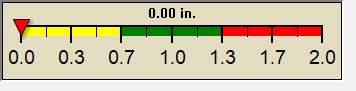
High Precipatation
none
Data courtesy of NWS-CPC
USA EXTREMES
High Temperature
111°F at Needles, CA
111°F at Palm Springs Asos, CA
Low Temperature
35°F at Yellowstone Lake, WY
High Precipatation
3.35in at Middle Peninsula Regional Airport, VA
Data courtesy of NWS-CPC
Alerts
Affiliations

 --------------------
 --------------------
 716-503-ANDY
--------------------
716-503-ANDY
--------------------